|
This page is intended to provide a little education in order to help more people aware of what is going on inside the clouds. It is our hope that you will be able to learn and in turn, be a bit more aware of what is approaching and the necessary steps or cautions you need to take. This is a work in progress.
Class is now in session!
|
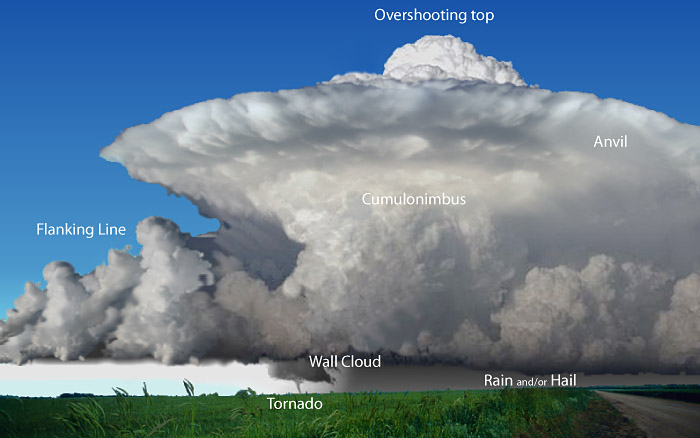 |
Classic Supercell
This type of cell is what produces the tornadic events, severe hail, copious amounts of rain and high wind. The flanking line is a marker for energy inflow to the main structure. An "anvil" (the semi-flattened disc area near the top) indicates there is a powerful updraft and good organization to the structure. The "knuckled" appearance of the edges of this disc are another indicator of the strength of the updraft. It is as if the cloud rose up and hit a ceiling, causing it to spread outward. The real indicator is the protruding mass that is above the anvil called an "overshooting top". This indicates not only the location of the main updraft, but it tells that the updraft is strong enough to punch through the anvil.
|
|
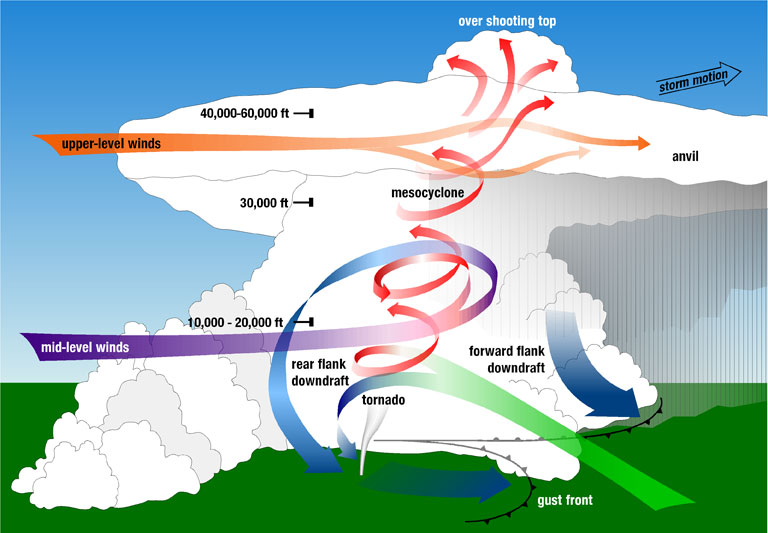 |
Wind Dynamics & Flows
Shown here, is how the updrafts, winds and energy interact with each other in order to form a supercell and the sometimes resultant tornado.
|
|
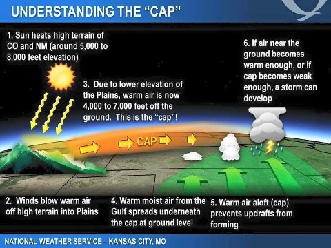
The "cap" as it is called, is one of the forces that can either prohibit or allow development of storms. A strong cap will hold down the rise of cells
and prevent further development. If the cap should be weak or weaken, development can occur. |
 |
|
A very good example of a wall cloud (photographer unknown).
Things to consider about a wall cloud: 1) Is it persistent, 2) is it rotating?, 3) is it rising?
Just because a wall cloud is present, it doesn't mean a tordano is eminent. Possible?....yes. Remember, wall clouds can dissipate, move, and regenerate.
|
 |
|
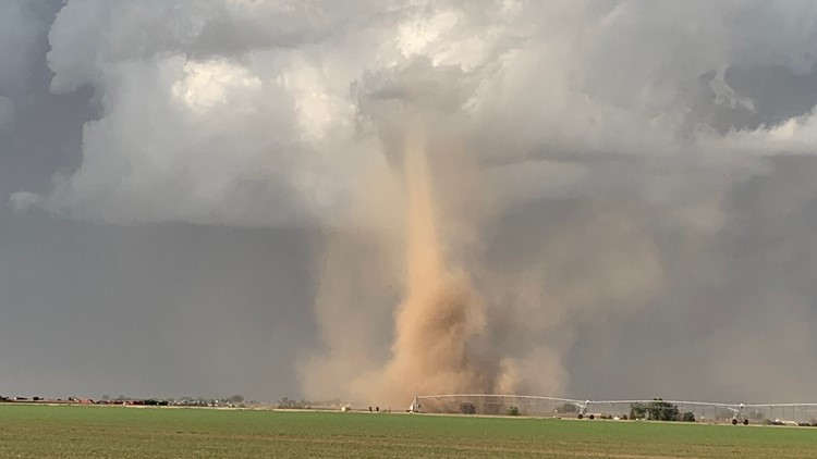
Landspouts are frequently reported as tornados. While that is partly true (they are a rotating column) they are not in the normal sense a true tornado.
Tornadoes form from the cloud down and have extremely strong winds and destructive power. First a funnel forms, usually from a wall cloud and then it reaches
down to the ground at which point it is considered a tornado.
Landspouts on the other hand are a result of converging air on the edge of a boundary that result in spinup from the ground up. These are usually associted
with storm system development and may reach up to join into a cloud. While they can at times do light damage, the wind speeds involved
are usually well below the 100 mph mark. They are also usually very short lived. They can be seen on the leading edge of an advancing system.
|
 |
|
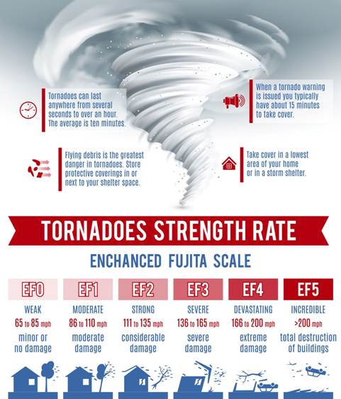
The Enhanced Fujita (EF) scale is what the strength of a tornado is measured by. Rating occurs after the storm, as it is a level of damage assessment.
Assessment includes estimating winds via destruction level on buildings, trees and other structures and is compared to historical known values. The Lubbock tornado
of 1970 contributed important data for Dr. Fujita as he developed the scale.
|
 |
|
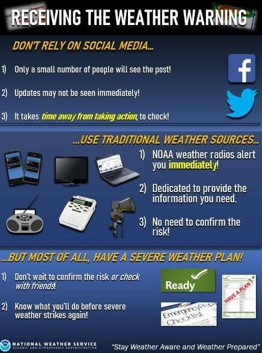
One of the things you can do to be prepared is to be certain that you will receive the warnings that are sent out by the National Weather Service.
Social media is NOT a reliable way of getting the information in a timely manner and the information you do see may be unreliable or worse, confusing.
Too often people post information that is either incomplete, questionable in it's legitimacy or just flat out wrong!
Instead stay with the traditional methods...NWS weather radios, commercial broadcast, email and text alerts you can sign up for from trusted sources.
Weather radios can be set so you receive only the warnings and alerts you choose to receive. Alerts and warnings can be confined to your county, expanded to cover surrounding
counties and other areas you may have a vested interest in.
Above all, have a plan. The national Weather Service has some very good guidance on putting together a plan.
|
 |
|
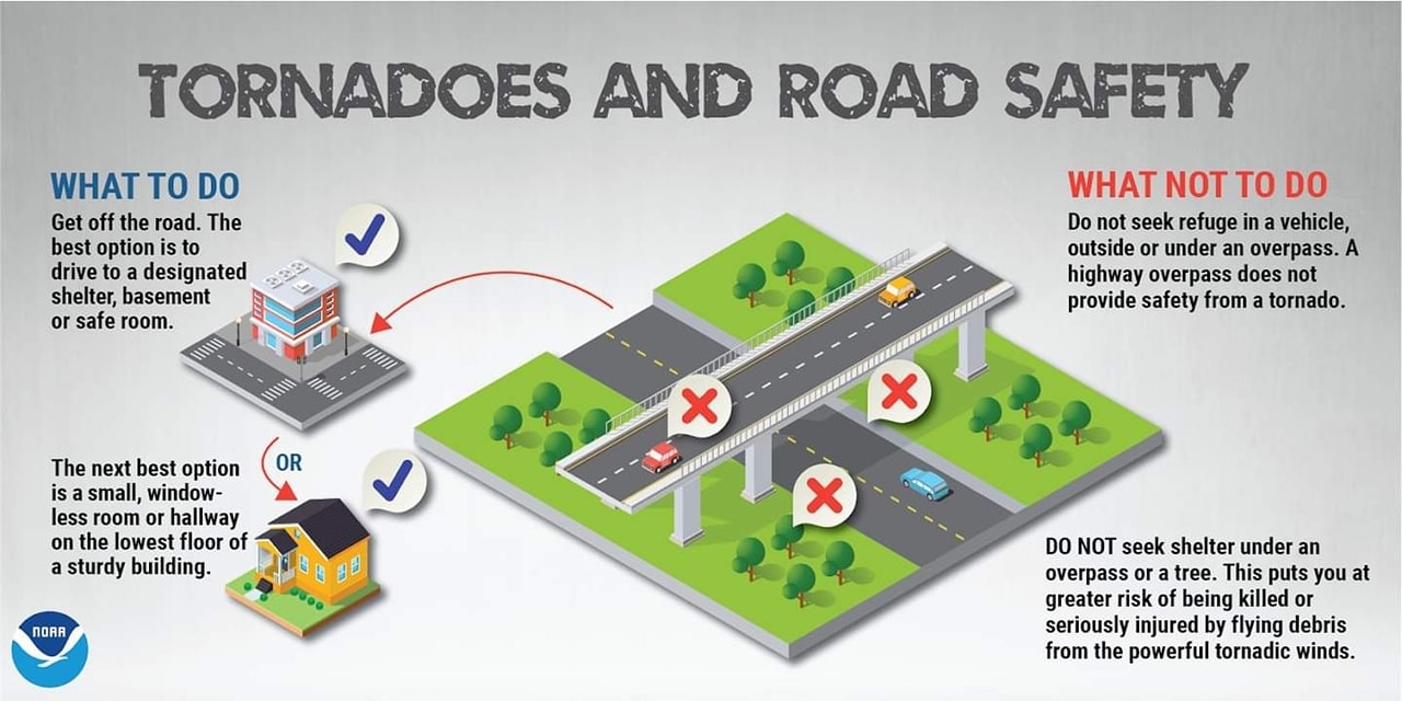
It may at first seem like a good idea, but it5 really isn't. Parking under an overpass during tornadic events will subject you to very intense winds.
The structure causes a 'focusing' effect and can reuslt in more serious injuries.
|
 |
|